Kilimanjaro
Machame Route
Machame Route
The Machame route, also known as whiskey route, is the most popular hiking route on Mt. Kilimanjaro. Approximately 50% of trekkers use the Machame Route to climb Mt. Kilimanjaro. The route is very scenic, with incredible views and varying landscapes.
The route allows acclimatization as we climb high and sleep low. From Shira 2 camp site (3,610m / 12,500ft ) we hike up to Lava Tower (4,650m / 15,190 ft ) and then descend to Barranco camp (3,901 m / 13,044 ft) to overnight.
Also the route allows days of few hours of hike and therefore hikers will have more time of resting before summit attempt. From Barranco camp to Barafu camp we will have two days of few hours of hike.
The summit attempt path from Barafu camp has less loose scree compared to the summit attempt path from Kibo Hut, making it slightly easier to reach the crater rim.
Machame Route Over View

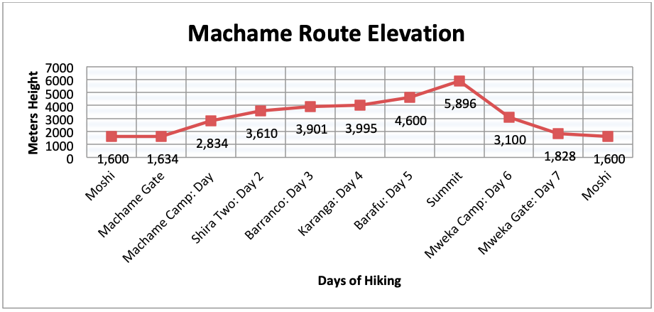
Day 1: Machame Gate to Machame Camp
Elevation:1,634m / 5,380ft to 2,834m /9,350ft
Hike time: 7 hrs
Distance: Approximately 11km / 7miles
Habitat: Rain forest

Machame Gate
After breakfast depart at 8:00 am and drive to Machame Gate. The drive from Moshi to Machame Gate will take about one hour. At the gate we will register ourselves to provide information about name, age, passport number and nationality. After signing in we will enjoy an easy hike through spectacular tropical rain forest. We will reach our campsite in the early evening for dinner and overnight.
Day 2: Machame Camp to Shira Two Camp
Elevation: 2,834m / 9,350ft to 3,610m / 12,500ft
Hike time: 6 hrs
Distance: Approximately 5.2 km/ 3 miles
Habitat: moorland and grassland.
From Machame camp we will have a relatively steep trek following a path up the steep rocky ridge to a semi-circular wall of rocks, known as Picnic Rock. At Picnic Rock we will have excellent views of Kibo. We will take our packed lunch at Picnic Rock after which we will hike across the gorge to reach Shira Two Camp where we will overnight.
Day 3: Shira Two Camp via Lava Tower then down to Barranco Hut
Elevation:3,610m / 12,500ft to 4,650m / 15,190ft then down to 3,901m / 13,044ft
Hike time: 7 hrs
Distance: Approximately 10.7 km
Habitat: Moorland

Shira camp
After breakfast we will hike to Lava Tower (4,650m / 15,190ft). The Lava tower is a volcanic rock tower that was formed by the volcanic activity that happened on the mountain many years ago. It is around 90m tall from the base. In the previous years, the tower used to be a point of interest for rock climbers, who would scale it to enjoy what is a 360 degree view of the surroundings and the peaks; however, this practice has been banned for safety reasons. This is one of the most valuable days for acclimatization. After a short rest at Lava Tower we will descend to Barranco Camp (3,901m / 13,044ft).
Day 4: Barranco Camp to Karanga Camp
Elevation: 3,901m / 13,044ft to 3,995m / 13,106ft
Hike time: 4-5 hrs
Distance: Approximately 5 km / 3 miles
Habitat: Alpine Desert
Start with tackling the awesome looking obstacle, the Barranco Wall, a steep and exposed wall of around 300m. The Barranco Wall is also known as Breakfastbecause it is the first thing we will tackle in the morning. The wall is near vertical, but the path cuts across it at a diagonal. The wall climb may take may be 1-2 hours of slow, relatively easy scrambling. After finishing the Barranco Wall we will reach elevation of 4,200m / 13,700 ft then we will cross ridges and valleys to Karanga Camp. This is a shorter day meant for acclimatization.
Day 5: Karanga Camp to Barafu Camp
Elevation: 3,995m / 13,106 ft to 4,600m / 15,331 ft
Hike Time: 4 hours
Distance: 4 Kms / 2 miles
Habitat: Alpine desert

It is another short hike meant for acclimatization, only taking just over 4 hours at a very modest pace. We will hike on ringing stones and the barren slope up onto a ridge. On the east across the saddle we will see Mawenzi, the second peak of Kilimanjaro, with its rough, jagged face. We will take our lunch and then try to get some rest during the afternoon, before having an early supper around 5 pm. We will use the rest of the day to prepare for the summit hike.
Day 6: Barafu Camp to the Summit and then to Mweka Camp
Elevation:4,600m / 15,331ft to 5,896 m / 19,341ft down to 3,100m /10,065ft
Summit time: 7 hrs
Descent time: 8 hrs
Distance: Approximately 4.5 km / 3 miles ascent and 10.8 km / 7 miles descent
Habitat: Stone scree and ice-capped summit, alpine desert, moorland.
It is a 15 – 17 hour day hike, depending on our speed and endurance, commencing at midnight and until the next afternoon or evening. We will be woken at 11.00pm to get ready for the summit attempt. We could have some soup if we wanted, but we will get a cup of tea and biscuits on the way. The steep climb over loose volcanic scree has some well-graded zig-zags and a slow but steady pace will take us to Stella Point (5,739m / 18,800) ft), in about five or six hours. We will rest there for a short time to enjoy the sunrise over Mawenzi. Those who are still feeling strong can make the two-hour round trip from here along the crater rim to Uhuru Peak (5,896m /19,345 ft), passing close to the spectacular glaciers and ice cliffs that still occupy most of the summit area to Uhuru “Independence” summit. After taking picture and celebration we will head back down the mountain, stopping at Barafu Camp to rest, and then heading down to Mweka Camp.
Day 7:Mweka Hut to Mweka Gate
Elevation:3,100m / 10,065ft to 1,828m / 5,380ft
Descent time: 4 hrs
Distance: Estimated distance: 10km
Habitat: Montane forest:

Mweka Gate
After breakfast, we will have a short celebration with our guides and porters. This is the time we may consider to pay tips if we are well satisfied with the service of guides and porters. Then we will hike for about 4 to 6 hours to the Mweka gate.
At Mweka gate we sign our names and details in a register. This is also where successful climbers receive their summit certificates. Those climbers who reached Stella Point (5,739m / 18,800 ft) are issued with green certificates and those who reached Uhuru Peak (5895m) receive gold certificates.
From the Mweka Gate we will drive back to Moshi for a long overdue hot shower and celebrations!!